 Contacto
 Como comprar
Entrega
Guia de compras
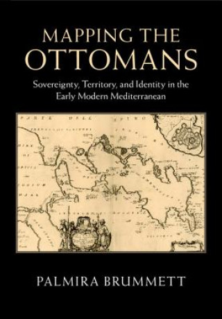
Mapping the Ottomans
Sovereignty, Territory, and Identity in the Early Modern Mediterranean
 Inglês
 121 b
121 b
Política de devolução de 30 dias
Os clientes também compraram


 /
/
 Capa mole
 43.08
€
43.08
€


Simple paradigms of Muslim-Christian confrontation and the rise of Europe in the seventeenth century do not suffice to explain the ways in which European mapping envisioned the 'Turks' in image and narrative. Rather, maps, travel accounts, compendia of knowledge, and other texts created a picture of the Ottoman Empire through a complex layering of history, ethnography, and eyewitness testimony, which juxtaposed current events to classical and biblical history; counted space in terms of peoples, routes, and fortresses; and used the land and seascapes of the map to assert ownership, declare victory, and embody imperial power's reach. Enriched throughout by examples of Ottoman self-mapping, this book examines how Ottomans and their empire were mapped in the narrative and visual imagination of early modern Europe's Christian kingdoms. The maps serve as centerpieces for discussions of early modern space, time, borders, stages of travel, information flows, invocations of authority, and cross-cultural relations.


Sobre o livro
Inglês
Categorias

Ofereça este livro hoje
É fácil
1 Adicione ao carrinho e escolha Entregar como presente ao finalizar a compra 2 Receberá um vale 3 O livro chegará ao endereço do destinatárioTambém pode estar interessado em


 /
Capa mole
12.53
€
/
Capa mole
12.53
€


Olá! Sou o Libroamiko, o seu conselheiro de livros.
Como posso ajudar?